
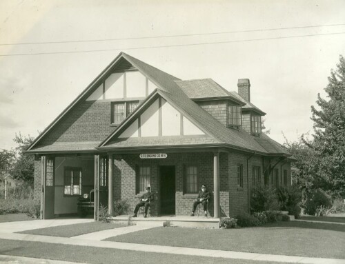
Rail station at Hall’s Ferry in 1915. It provided a connection between the Oregon Electric Railway and the ferry. A small incline vehicle on rails took passengers from track level to river level. WHC 2007.001.0398
“We recently bought a piece of property out River Rd. past the island, but before the first railroad overpass,” so their story began. The couple that walked through the Research Library doors began their archival quest like so many others had before them with a piece of property or a family story that they wanted to know more about. In this case, the couple sought a “sense of place”, a connection to their newly adopted city and state, the land on which they walked and the home in which they lived. They had recently moved from out-of-state, bought an older home with property, and from the number of neighbors and passers-by with stories to share, suspected there might be something more.
One passerby shared a story about a dance hall that had been built on the property and the people that would ride the Oregon Electric Railway out for the dances held on Saturday nights. A neighbor confided that the home the couple had bought used to be a schoolhouse. And yet another had stopped by with the story of yearly rodeos held on the property. Exciting to be sure, but true? “Where do we begin?” they wanted to know.
We started by pinpointing their property on a current map, looking particularly for the township, range, and section coordinates. Using this standardized grid system developed by the U.S. Government’s General Land Office (now Bureau of Land Management) back in the early 1800s would allow us to easily trace the property’s location through time and across a variety of maps including the Marion County Geographic Information System (GIS) database available online through the Marion County Assessor’s Office.
Then we moved to a series of Metsker maps from the 1920s, 1940s, and 1970s available in our library. This allowed us to step our way back through time, physically tracking how the property ownership changed. We also consulted the free online Metsker maps at HistoricMapWorks.com to help fill in the gaps. Unlike many of the map publishers of the time who limited themselves to publishing maps of more developed areas, the Metsker family excelled at recording the history of the then rural and wilderness geographies. This makes them invaluable for tracing land ownership of undeveloped areas and how it changed over time, particularly for our researchers.
We discovered that the property the couple had purchased was in Halls Ferry, approximately 9 miles south of Salem, on the eastern shore of the Willamette River. The area was named for a ferry operated by Benjamin Franklin Hall from 1884-1902 and in its heyday boasted a store, post office, school, cemetery and railway station. The area was primarily agricultural and boasted bumper crops of hops, loganberries, apples and onions. A school location was identified on two of the Metsker maps, without further identifying details such as proper name or specific location on the property which was originally owned by the Riverview Land Company. No clues of a dance hall or rodeo grounds appeared on the maps.
We definitely needed to fill in some informational gaps, starting with the school. A quick glance at the book Early Schools of Marion County provided a few more clues and a rudimentary, unscaled map with school locations in that area. Halls Ferry School seemed the most likely, but the book included no address or identifying years of operation. Next step, a visit to the Oregon State Archives web page to check their historical records inventory for available Marion County school records pertaining to Halls Ferry School. Still not the level of detail that we were looking for in order to tie the home-owner’s property to the school location.
So where to fill in the information gaps? How to better gain a sense of place beyond land descriptions and names on paper? Newspapers, of course. We started with the Historic Oregon Newspaper Project online, searching with the name “Halls Ferry School” and noticed that many of the search results were found in a section of the Capitol Journal newspaper titled “Willamette Happenings.” Within this section of the paper were posted folksy letters written by community correspondents throughout the Willamette Valley. Published once a week in the Saturday edition of the paper, you might find news about your city or community in Marion County. This proved to be a goldmine, especially once we switched to the Library of Congress website, Chronicling America: Historic American Newspapers and found successive issues of the Capitol Journal (1888-1980) available to give us weekly news updates of the Halls Ferry community we were interested in.
Here we found the minutiae, what might seem to be trivial details of the people coming and going, roads being built, births and deaths, bumper crops, crime reports, etc. Trivial unless it’s your ancestor, or in this case, property owner. In the February 23, 1917 issue of the Capitol Journal newspaper we found “the people of Halls Ferry…enthusiastically congratulating themselves in having attained a school. It was sorely needed as many children in the immediate vicinity have long been deprived of the necessary schooling which each and every child is rightly entitled to.” Further articles listed special school meetings electing directors, issuing thank-you votes to Mr. Croisan and the Riverview Land Company who donated the land for the school, surveyors, bond measures, and so forth. One of the more interesting details picked up in the March 26, 1917 edition was a description of the land as being “just east of Halls Ferry station, about thirty rods… (with) a fine grove of oak maple and fir timber on the tract.” This perfectly matched both the property owner’s description and our map research.
The rail station at Hall’s Ferry as seen in the picture circa 1915, was a unique design that had not previously been used in Oregon. Halls Ferry station was the connection between the Oregon Electric Railway and the small motor launch that took passengers via the river to Independence, Oregon. A small incline vehicle on rails took passengers from track level to river level.
What about the dance hall? In the March 2, 1917 issue of the Capitol Journal we read that “E.B. Smith and co-proprietors of “Veita Springs” have arranged to make extensive improvements within the next few months, one of which will be a large dancing pavilion, concrete floor 50 x 80 feet, and the building of a number of cottages for those wishing to camp and for week end visitors; also making a fine parking place for automobiles.” Another clue to follow-up on. And the rodeo grounds? That is still a mystery in progress.
It is often a combination of characteristics that make a place special and unique. With a sense of place we feel welcome and connected to our property, our neighbors, the community, particularly as we become familiar with not only its physical features, but the knowledge and folklore related to it. As Kent Rydon so eloquently wrote, “a sense of place results gradually and unconsciously from inhabiting a landscape over time, becoming familiar with its physical properties, accruing history within its confines.”
This article was written by Kaylyn F. Mabey for the Statesman Journal where it was printed 19 April 2015. It is reproduced here for reference purposes.
References:
- Marion County Geographic Information System
- Metsker Maps – 1920-1990
- HistoricMapWorks.com
- Oregon State Archives – Historic Record Inventory
- Early Schools of Marion County – Marion Intermediate Education District
- Historic Oregon Newspaper Project – University of Oregon
- Chronicling America: Historic American Newspapers – Library of Congress Digital Newspaper Project
- Capitol Journal (1888-1980)
- “Willamette Happenings” Capitol Journal, February 23, 1917
- “Willamette Happenings” Capitol Journal, March 2, 1917

Wasn’t this railway station originally called East Independence?