Marion County, Oregon had at one time at least 144 different public school districts. These districts ranged in size from a single one-room school house, to larger city districts with multiple schools. Over time many of these smaller school districts were merged and consolidated. Today (2022) only 12 public school districts remain.
Because of the complex administrative history of these many districts, records are spread far and wide, and often utilize different naming systems. This finding aide has been created to help demystify the historical numbering/naming system and provide a list of these Marion County School District Records available at the Willamette Heritage Center.
Check out the Marion County Records Guide created by the Oregon State Archives (another large repository of Marion County School District Records) for an inventory of records they have found at a variety of institutions: Marion County Records Guide -> Scroll down to School District Records.
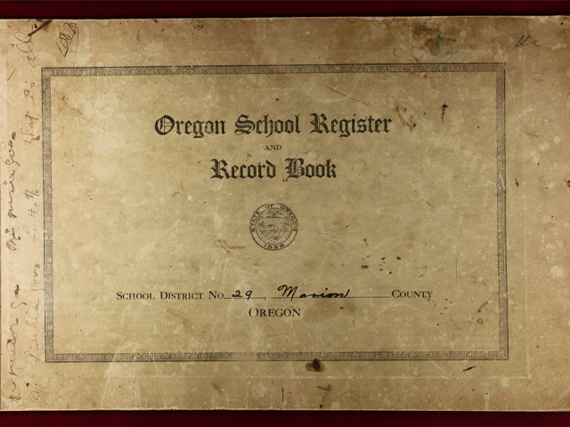
Standard School Record Book for the Rocky Point School located near Aumsville, Oregon. WHC Collections 2009.093.0001. These ledgers kept a list of students names and attendance in the district school as well as other things. Scroll down this page to find a list of all Marion County School District Records in the WHC’s collections.
How to Use This Guide
This guide consists of several parts:
- Map of Historical Marion County School Districts
- Numerical List of Known Marion County School Districts
- Inventory of Collections Materials at the Willamette Heritage Center Related to these districts
Scroll to access these different elements. You can also search this page by using the keyboard shortcuts CTL + F to search for a school name inside all of these records.
This is just a list of materials available. To learn more about accessing records at the Willamette Heritage Center visit our research page
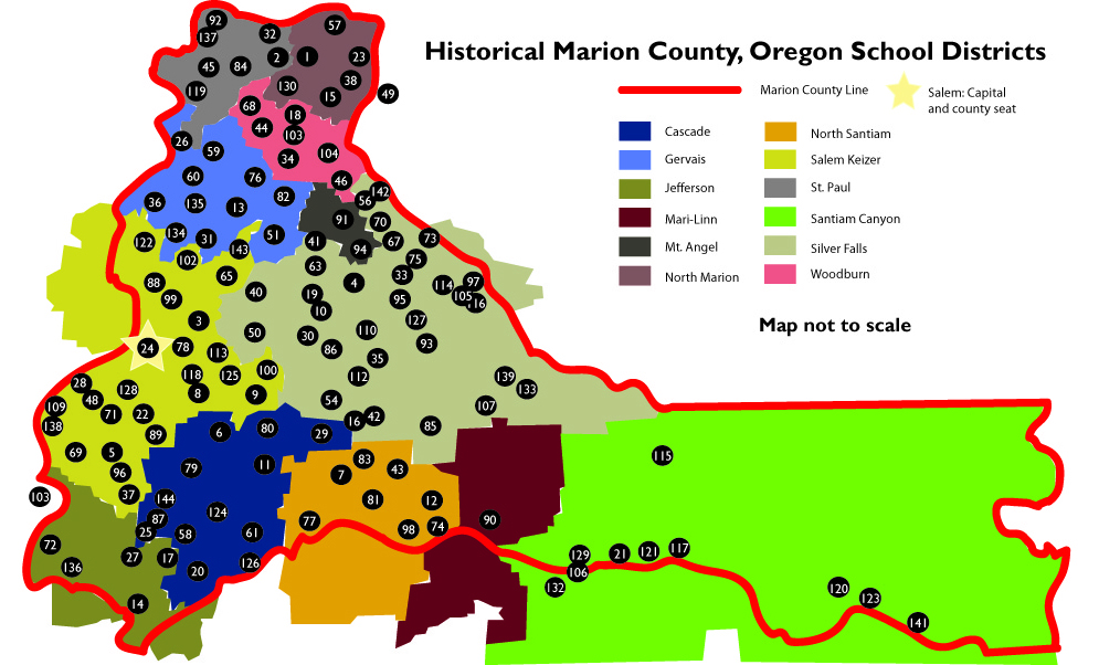
This map was created utilizing a number of sources including:
Early Schools of Marion County, 1976
Ledger of Teachers Contracts for Marion County Schools, 1911-1915 WHC Collections 2008.066.0001
Metsker’s Map of Marion County, 1929
Newspaper Records
This map is not to scale and is meant to provide an approximate location to help start searches. Numbered school districts (keeping in mind that many smaller districts consisted of a single school until later consolidations) are overlaid on an approximation of modern districts. A numerical list of school districts can be found below. You can search for a school district name by using keyboard shortcuts CTRL+F and typing in the name of the school. Note inconsistencies in the records are common and noted in the list below where possible.
Download a copy of the map here. Map created by the Willamette Heritage Center, 2022.
Marion County School Districts by District Number
| No. | District Name | A.K.A. | Map Key | Notes |
|---|---|---|---|---|
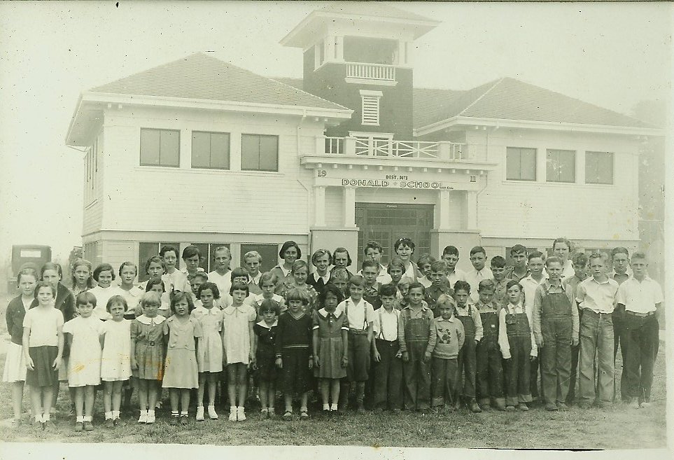
| 1 | Donald | North Marion | ||
| 2 | Arbor Grove | Case | St. Paul | |
| 3 | Middle Grove | Salem | ||
| 4 | Silverton | Silverton | ||
| 5 | Rosedale | Salem | ||
| 6 | Witzel | Cascade | ||
| 7 | Sublimity | North Santiam | ||
| 8 | Rickey | Salem | District School No. 8 is illustrated in the 1878 Atlas of Marion and Linn County as being located in section 32, Township 7 South Range 2 West. | |
| 9 | Macleay | Salem | ||
| 10 | Evergreen | Silver Falls | ||
| 11 | Aumsville | Cascade | ||
| 12 | Fern Ridge | North Santiam | ||
| 13 | Manning | Pioneer | Gervais | |
| 14 | Jefferson | Jefferson | ||
| 15 | Hubbard | North Marion | District School No. 15 is illustrated in the 1878 Marion and Linn County Atlas on the property of W. Gomley in Township 5S range 1 West, section 4. | |
| 16 | Oak Grove | Silver Falls | 1929 Metsker’s Map shows school between sections 12 and 13 T8S R1W | |
| 17 | Parrish Gap | Jefferson | ||
| 18 | Hall | Woodburn | District School No. 18 is shown in the 1878 Marion and Linn County Atlas in Section 7 of Township 5 south Range 1 West of the Willamette Meridian. | |
| 19 | Brush Creek | Silver Falls | ||
| 20 | Marion | Cascade | ||
| 21 | Gates | Santiam Canyon | ||
| 22 | Pringle | Salem | ||
| 23 | Aurora | North Marion | ||
| 24 | Salem | Salem | ||
| 25 | Battle Creek | Squirrel Hill; Capital School; Illihee/Illahe | Cascade | 1929 Metsker Map, Section 2 T9S, R3W. Not to be confused with Ilihee (#28) |
| 26 | Fairfield | Gervais | 1878 Atlas of Marion and Linn Counties shows Fairfield School located T5S R3W Section 13. Read more about Fairfield and the school here. | |
| 27 | Looney Butte | Jefferson | ||
| 28 | Ilihee | Salem | Not to be confused with Battle Creek/Illihee (#25) | |
| 29 | Rocky Point | Cascade | 1929 Metsker’s Map shows school in southwest quadrant of section 15, T8 SR 1 W | |
| 30 | Willard | Liberty | Silver Falls | Note 1929 Metskers Map of Marion County shows separate entries for Liberty School and Willard School, suggesting at least two school buildings within the district |
| 31 | Brooks | Gervais | ||
| 32 | Champoeg | St. Paul | ||
| 33 | Evans Valley | Evans | Silver Falls | |
| 34 | Belle Passi | Woodburn | ||
| 35 | Silver Cliff | Silver Knob | Silver Falls | |
| 36 | Mission Bottom | Gervais | ||
| 37 | Fairview | Ankeny | Salem | |
| 38 | White | North Marion | District School No. 38 is illustrated in the 1878 Atlas of Marion and Linn County as being located in Township 4 South Range 1 West Section 36. | |
| 39 | To date could not find records of school district with this numerical designation | |||
| 40 | Central Howell | Silver Falls | ||
| 41 | Hazel Dell | Lone Butte | Silver Falls | District School No. 41 is illustrated in the 1878 Atlas of Marion and Linn Counties as being located in section 16, Township 6 south range 1 West on property owned by the heirs of “H. Stafford.” |
| 42 | Union Hill | Victor Point | Silver Falls | These two merged, but were two separate districts. This number currently marks Union Hill. See number 112 for Victor Point; Union Hill School in 1929 Metsker’s Map shown T8S R1E east half of section 18. Comparing to modern County Assessor’s map, this appears to be the north side of what is now Hwy 214, just west of the intersection with Drift Creek Road SE |
| 43 | Independence | North Santiam | ||
| 44 | West Woodburn | Woodburn | ||
| 45 | St. Paul | St. Paul | ||
| 46 | McKee | Woodburn | ||
| 47 | To date could not find records of school district with this numerical designation | |||
| 48 | Croston | Livesley, Roberts | Salem | |
| 49 | Whiskey Hill | North Marion | Out of order in 2008.066.0001 Teachers Contracts (listed on page 242) |
| No. | District Name | A.K.A. | Map Key | Notes |
|---|---|---|---|---|
| 50 | Pratum | Silver Falls | District School No. 50 is illustrated in the 1878 Atlas of Marion and Linn Counties as being located between sections 23 and 24, Township 7 South Range 2 W. | |
| 51 | North Howell | Gervais | ||
| 52 | No records have been found with this district number | |||
| 53 | No records have been found with this district number | |||
| 54 | McAlpin | Silver Falls | 1929 Sanborn Map shows School in southeast quadrant of Section 4, T8S R1W | |
| 55 | No records have been found with this district number | |||
| 56 | Grassy Pond | Silver Falls | ||
| 57 | Butteville | North Marion | ||
| 58 | Pleasant View | Cascade | ||
| 59 | St. Louis | Gervais | ||
| 60 | Eldridge | Gervais | ||
| 61 | West Stayton | Cascade | ||
| 62 | Milster | Possible duplicate of #94. Listed this way in 2008.066.0001 Teachers Contract Book | ||
| 63 | Bethany | Silver Falls | ||
| 64 | No records have been found with this district number | |||
| 65 | Hazel Green | Salem Keizer | ||
| 66 | No records have been found with this district number | |||
| 67 | Thomas | Silver Falls | ||
| 68 | Johnston | Woodburn | ||
| 69 | Prospect | Salem Keizer | 7085 Skyline Road | |
| 70 | Harmony | Silver Falls | ||
| 71 | Liberty | Salem Keizer | ||
| 72 | Sidney | Ankeny | Jefferson | |
| 73 | Scotts Mills | Silver Falls | ||
| 74 | Mehama | North Santiam | ||
| 75 | McLaughlin | Silver Falls | ||
| 76 | Gervais | Gervais | ||
| 77 | Stayton | North Santiam | ||
| 78 | Swegle | Salem Keizer | ||
| 79 | Turner | Cascade | ||
| 80 | Shaw | Cascade | ||
| 81 | Oak Glen | North Santiam | ||
| 82 | Parkersville | Gervais | ||
| 83 | Triumph | North Santiam | ||
| 84 | Four Corners | St. Paul | District School No. 84 is illustrated in the 1878 Atlas of Marion and Linn Counties as at a cross-roads near the center of section 21, Township 4 South Range 2 West. | |
| 85 | Silver Creek Falls | Silver Falls City | Silver Falls | |
| 86 | Center View | Centerview | Silver Falls | 1929 Metskers Map shows the school in Township 7 S Range 1 West Section 22, located on the east side of the Silverton-Willard Road (now Cascade Highway) and just north of intersection with Pratum-Willard Road (now Sunnyview Rd NE). Newspaper article in the Oregon Statesman (24 June 1967) states “Centerview school district consolidated with Victor Point Many years ago. The school was torn down and property returned to farm land.” Marion County History (Volume XIV -1983/84 pg 57) reads: Enrollment at the school ranged from high of 32 to less than six pupils when the district consolidated with Victor Point in 1947. Later the building was razed and some of the lumber used in the construction of a new home in the district. Contradictory source (photo at the WHC 1999.003.0019) says the building became Waldo Hills Community Hall (now located across Cascade Highway). |
| 87 | Summit | Cascade | ||
| 88 | Keizer | Salem Keizer | District School No. 88 is illustrated in the 1878 Atlas of Marion and Linn Counties near the intersection of sections 34 and 35 (Township 6 South Range 3 West) and Sections 3 and 2 (Township 7 South Range 3 West). | |
| 89 | Pleasant Point | Salem Keizer | ||
| 90 | Oakdale | Mari Linn | ||
| 91 | Mt. Angel | Mt. Angel | Also number assigned to Geelan (Later 92) | |
| 92 | Geelan | St. Paul | Also at one time labelled No. 91 | |
| 93 | Mountain View | Havernick | Silver Falls | |
| 94 | Milster | Mt. Angel | Duplicate of No.62 or was 62 a separate district? | |
| 95 | Davis | Silver Falls | ||
| 96 | Sunnyside | Salem Keizer | ||
| 97 | Crooked Finger | Silver Falls | Is it possible Crooked Finger (97) and Abiqua (105) are same school? So close together in maps. | |
| 98 | Howell | Powell, Alder Creek | North Santiam |
| No. | District Name | A.K.A. | Map Key | Notes |
|---|---|---|---|---|
| 99 | Hayesville | Salem Keizer | ||
| 100 | Oak Ridge | Salem Keizer | ||
| 101 | No records found with this district number | |||
| 102 | Perkins | Maplewood | Salem Keizer | |
| 103 | Woodburn | Woodburn | ||
| 104 | Union | Woodburn | ||
| 105 | Abiqua | Dunigan | Silver Falls | Depicted on 1929 Metsker’s Map T6S R1E S half of section 28. Possible Crooked Finger (97) and Abiqua (105) are same school, so close together in maps? |
| 106 | Taylor | Santiam Canyon | Article Oregon Statesman 18 May 1932 pg 5 describes school as “on the ridge south of Mill City.” Map placement is based on that. | |
| 107 | Hullt | Silver Falls | ||
| 108 | Unnamed District | Santiam Canyon | Not listed the Marion County Teachers Contract’s Ledgers WHC 2008.066.0001. Is listed in Early Schools in Marion County, 1976. | |
| 109 | Riverside | Salem Keizer | Note “Improvements at Riverside School Lauded” Capital Journal 19 April 1929 pg 1, also calls it Riverview school — could this be related to River view/Hall’s Ferry School (138) and just another number assigned? “Only Five One Room School houses Remain in Marion County.” Capital Journal 15 April 1955 has picture and describe it on South River Road near Salem. | |
| 110 | Valley View | Pleasant View; Fair View | Silver Falls | |
| 111 | No records found for a district with this number. | |||
| 112 | Victor Point | Silver Falls | See 42 for Union Hill on Map. These two districts merged and both went by 42 at one point. | |
| 113 | Fruitland | Salem Keizer | ||
| 114 | Brier Nob | Briar Knob | Silver Falls | |
| 115 | Elkhorn | Santiam Canyon | 1929 Metsker’s Map shows T9S R3E north half of section 11 | |
| 116 | Noble | Silver Falls | 1929 Metsker’s Map shows school in on border between south halves of sections 35 and 35 T6S R1E | |
| 117 | Niagara | Santiam Canyon | ||
| 118 | Auburn | Salem Keizer | ||
| 119 | Mahony | St. Paul | ||
| 120 | Hall’s Camp | Santiam Canyon | Not finding on maps from 1929 (Metsker’s) nor 1976 Early Marion County Schools. “County to Maintain Old Hall’s Camp Road” described it as “four miles west of Detroit.” Location on map is guess based on this description | |
| 121 | Minto | Santiam Canyon | ||
| 122 | Clear Lake | Salem Keizer | ||
| 123 | Detroit | Santiam Canyon | ||
| 124 | Crawford | Cascade | ||
| 125 | Bethel | Salem Keizer | ||
| 126 | North Santiam | Cascade | Not to be confused with later Unified District Title/Map Key | |
| 127 | Porter | Silver Falls | ||
| 128 | Salem Heights | Salem Keizer | ||
| 129 | Mill City | Santiam Canyon | ||
| 130 | Broadacres | North Marion | ||
| 131 | Cloverdale | Cascade | See Also No. 144 | |
| 132 | Fox Valley | Gooch | Santiam Canyon | Now in Linn County, but was at one time administered by Marion County |
| 133 | Cedar Cap | Bridge Crest | Silver Falls | |
| 134 | Buena Crest | Gervais | ||
| 135 | Waconda | Gervais | ||
| 136 | Talbot | Jefferson | ||
| 137 | Raybell | St. Paul | ||
| 138 | Halls Ferry | Riverview | Salem Keizer | Could this be related to Riverside (No.109)? |
| 139 | Abiqua Heights | Silver Falls | ||
| 140 | Unnamed District | Silver Falls | ||
| 141 | Idanha | Santiam Canyon | ||
| 142 | Monitor | Silver Falls | ||
| 143 | Labish Center | Salem Keizer | ||
| 144 | Cloverdale | Cascade | See Also No. 131 | |
Other Schools mentioned in Early Schools of Marion County, but not given with district numbers are represented below
| No. | Name | A.K.A. | Map Key | Notes |
|---|---|---|---|---|
| ? | Cooley | Colley | Woodburn | |
| ? | Fargo | North Marion | ||
| ? | Lutheran | Luthern | Silver Falls | 1929 Metsker’s Map shows in the southwest corner of section 6 T6S R1E |
| ? | Kaufman | Silver Falls | ||
| ? | Waldo Hills | Silver Falls | ||
Inventory of Marion County School District Records at the WHC
Types of Records
The Willamette Heritage Center maintains a variety of materials documenting Marion County School Districts. These include things like:
- Photographs
- Scrapbooks
- District Directories
- Oregon School Record Books
- Individual Report Cards
- Diplomas
- Teachers Contracts and certificates
- Oral History Interviews
The collections at the WHC are not comprehensive. Most were acquired by individual donors. The one exception to this is a large collection of Salem-Keizer School District records. Check out the finding aide for these records here: https://www.willametteheritage.org/salem-keizer-school-district-records/
Inventory Coming soon!
General Marion County Schools Records at the WHC
Records
- Ledger of Teachers Contracts for Marion County Schools, 1911-1915 WHC 2008.066.0001
Directories
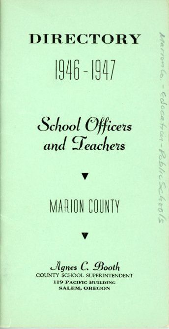
- Marion County School Directory, 1946-1947 WHC X2018.008.0038
Oral History Interviews
- Interview with Marion County Schools Superintendent Agnes Booth, 1962 WHC X2012.031.0012 (see link above)

