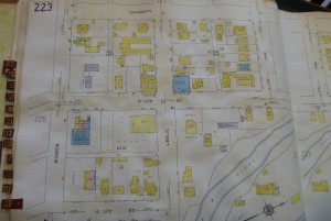
The Willamette Valley Genealogical Society printed an article on Sanborn Maps found in the Oregon State Library collections in their latest newsletter. These maps are phenomenal resources. Originally created for fire insurance purposes they are some of the most detailed resources for the history of the built environment. They will show building footprints and sometimes information about the use of the buildings. I was really excited to read through the index of maps held on microfom at OSL. The index is available online and includes a number of early Marion County cities including Aurora, Canby, Gervais, Hubbard, Mill City, Mt. Angel, St. Paul, Salem, Silverton, Stayton, Turner and Wooburn. The online index can be found here: http://www.oregon.gov/OSL/GRES/docs/sanmap2.pdf.
The Willamette Heritage Center currently holds three sets of Sanborn Maps. It is wonderful to look at the original maps, many of which have buildings color coded to describe the building and roofing materials. These original maps, however, were often added to over the years, meaning that our maps published in the 1920s really reflect the 1960s because of the forty years of pasted in updates. This additional resource of older maps at the Oregon State Library will give some older views of the city.
It should also be noted that the Salem Public Library has a subscription to an online database of Sanborn Maps which is useable at their facility. It also provides a broader date range of information and geographical scope.





Confirmed with the reference librarian last night. And if you don’t have a Salem Library Card (and it has to be Salem, not from the Chemeketa Cooperative partners), you can still use it at the library.
No, I’m pretty sure you can access the Sanborn’s from home with a Salem Library card!
Here’s the library’s “family and history” page with the link, and here’s the specific Sanborn login page, which requires a Salem card. The library offers maps for “over 170 cities in Oregon.”